- Home >
- Join Us >
- Enrolments >
- Enrolment Zone Map
Enrolment Zone Map
An indicative map of Rangiora High School's enrolment zone is available below.
Please note, the map is indicative only. The official description of the enrolment zone appears below.
Current Enrollment Zone
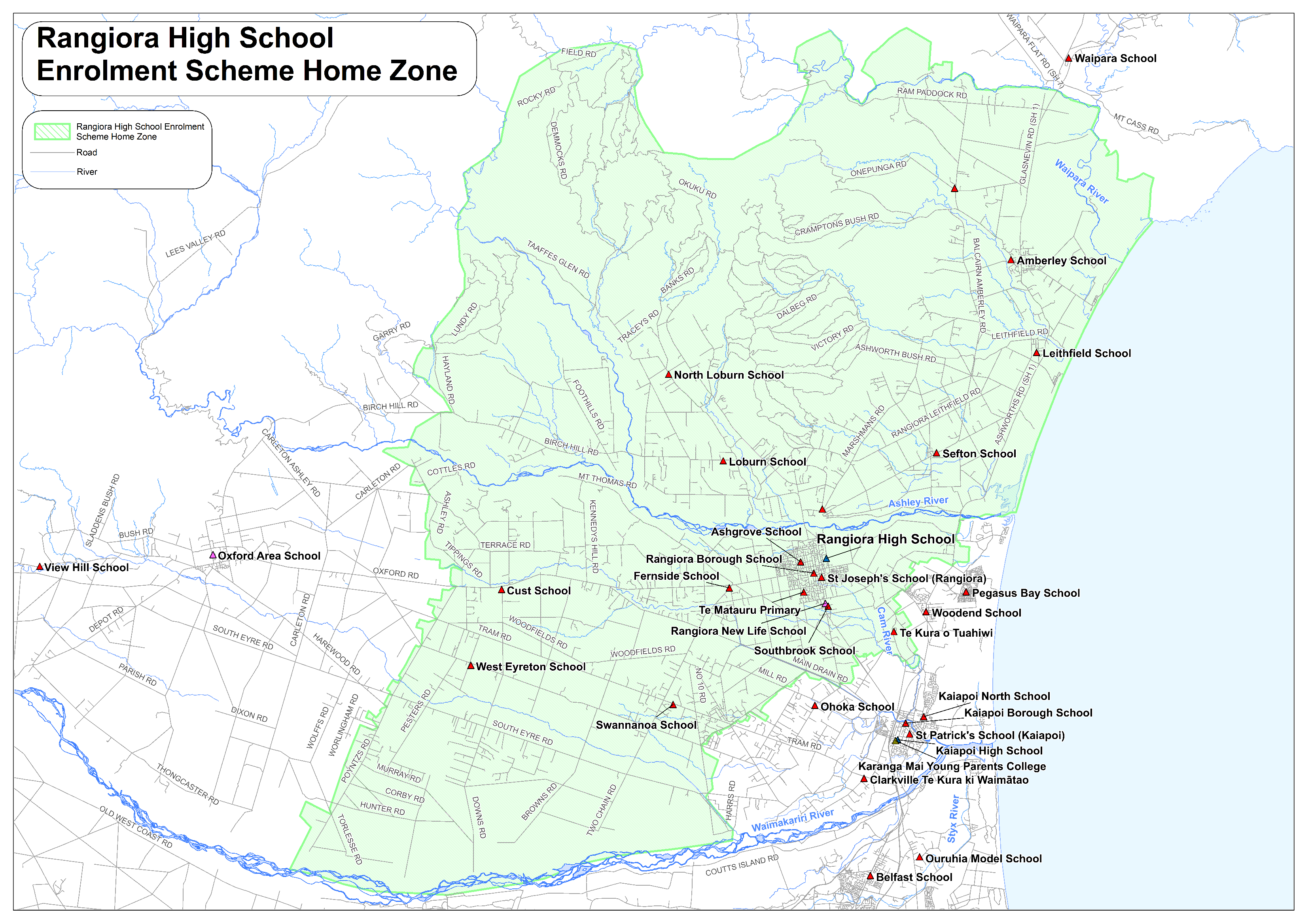
Description of the Rangiora High School Enrolment Zone
Home Zone
All students who live within the home zone described below shall be eligible to enrol at the
school.
Starting from the Diversion Road / South Eyre Road intersection;
• East along South Eyre Road to No. Ten Road
• North along No. Ten Road to McHughs Road
• North East along McHughs Road to the Tram Road / Bradleys Road intersection
Including Brennan Lane
• North East along Bradleys Road to Main Drain Road
• South East along Main Drain Road to Threlkelds Road
• North along Threlkelds Road to Flaxton Road
• North along Flaxton Road to Fernside Road
Including Camwell Park
• South East along Fernside Road to Lineside Road / Power Road intersection
• East along Power Road, through to the Bramleys Road bridge over the Cam River
Including 151, 153 and 153a Bramleys Road
• North East along Bramleys Road to Tuahiwi Road
• South along Tuahiwi Road to Church Bush Road
Including Cox Road addresses east of the Cam River
• North East along Church Bush Road to Greens Road
• North West along Greens Road to Tuahiwi Road
• North West along Tuahiwi Road to Okaihau Road
• North East along Okaihau Road to Rangiora Woodend Road
Including addresses on Gatehouse Lane
• North West along Rangiora Woodend Road to Gressons Road
• North East along Gressons Road to Main North Road (SH 1)
Including Waiora Lane
Including Main North Road (SH 1) between Gressons Road and Preeces Road
• North East along Main North Road (SH 1) to the Ashley River
• East along the North bank of the Ashley River to the coastline
• North along the coastline to the Waipara River
• North West along the south side of the Waipara River to Laidmore Road
Including any addresses on Double Corner Road, Stringers Road and Laidmore
Road north of the Waipara River
• South along Laidmore Road to the intersection with Ram Paddock Road
• From the Laidmore Road / Ram Paddock Road intersection South West (across country) to
the western end of Onepunga Road, then south west (across country) to the western end of
Taaffes Glen Road.
Including any addresses accessed from Quarry Road
• From the western end of Taaffes Glen Road, south west (across country) to the north
western end of Hayland Road
• South along Hayland Road to Birch Hill Road
• West along Birch Hill Road to Rakahuri Road
• South along Rakahuri Road to the south end of the road
• South across the Ashley River to Bowicks Road
• South West along Bowicks Road to Ashley Road
Including addresses on Ashley Road North of Bowicks Road
• South along Ashley Road to Tippings Road
• South East along Tippings Road to Oxford Road
• West along Oxford Road to Poyntz Road
Including address 1932 Oxford Road
• South West along Poyntz Road to the Waimakariri River
Including Eastwick Lane
• East along the northern bank of the Waimakariri River to Diversion Road
• North along Diversion Road to South Eyre Road
Addresses on both sides of boundary roads are considered in-zone unless specified otherwise.